A “Dam” Good Walk
- Visit North Central
Story & Photos by Joe Adamowicz
 Searching for a great spot to stretch your legs, enjoy a quiet lunch, and encourage the family to explore the local wilderness? The Birch Hill Dam Road in South Royalston may be just what you’re looking for!
Walk, Look and Listen!
This 2 ½ mile walk starts just beyond a yellow gate and runs parallel to a railroad track, and you may be treated to the sights and sounds of a freight train of the Pam Am Railway rumbling by. Note, too, the old telegraph poles with glass insulators— used to prevent electric current loss during transmission—adjacent to the tracks.
In five minutes you’ll come to a stream— Beaver Brook— flowing in an “S” pattern through a wetland. The brook’s name is an apt one, as gnawed trees are evidence of that large rodent’s work.
In spring, the long, matted tawny grasses and pale green foliose lichen splotched on maple, pine and birch trees contrast against the dark mirror of blue water to make an eye-pleasing sight.
Foliose lichens, flat and leaf like, usually grow in a circular pattern and look like odd-shaped lettuce.
The trail continues past a pine populated hillside with an impressive horizontal rock ledge at its base.
The next 15 minutes offer a long straight stretch. You’re apt to hear the tapping of a woodpecker, and see an interesting variety of mosses growing alongside the road. Passing a wetland, in early spring you will hear a deafening chorus of peepers and the cackling of wood frogs.
Soon the forest community changes as hemlock mixes in with pine, and Mountain Laurel provides a ground cover.
After moving past several ancient, moss-covered concrete pilings, you’ll notice mounded ridges on either side of the road. These are actually eskers: long, narrow ridges of sand and gravel left behind by a flowing stream of glacial meltwater. A small waterfall tumbles down a hillside to the right.
In spring, look for clouds of bluets, also called Quaker Ladies, nuns, or blue-eyed beauties, growing alongside the road. Twenty minutes into the hike, you will reach a metal gate that borders either side of the road as it moves uphill. In late May, the strikingly beautiful pink flowers of rhodora shrubs grace the hillside, their brilliant color a showy contrast to other drab plants that have barely shrugged off the cold. As you continue uphill, look to the right for another seasonal waterfall, then a patch of juniper and a picnic area.
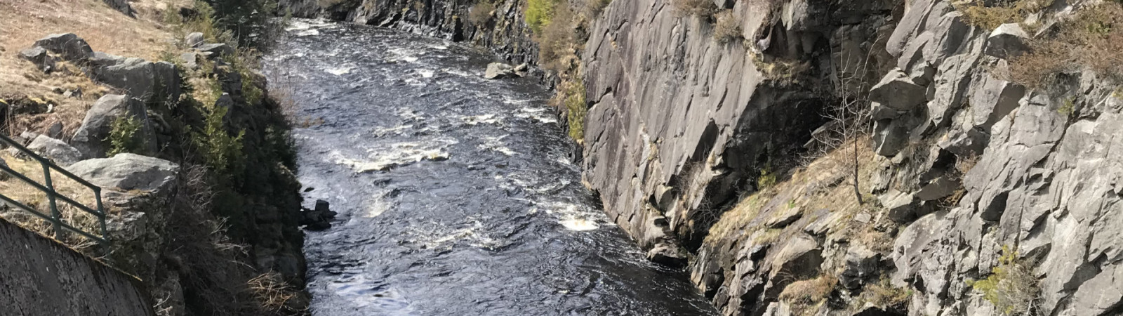
 See the Surge
The road bends left and continues for 1,400 feet over the dam, which is made of rolled earth with a rock slope protection. Your hike ends at the US Amy Corps of Engineers office and a recreation area. Walk over to the brick gate house, which regulates the amount of water released downstream by raising or lowering four 6-by-1-foot gates. Using caution, step up onto the concrete curb and peer over the green metal post fence to the churning whitewater 30 feet below, watching it surge through a narrow, steep sided granite gorge (dam outlet channel). Now move to the other side of the brick building and do the same thing, noting the contrast as the river calmly flows into the gatehouse.
After your walk, if you’re still in the mood for hiking, there are miles of old roads and trails in the Birch Hill Dam Recreational area. Feel free to explore!
About the Dam
Completed in 1941, Birch Hill Dam was one of the first dams built by the Army Corps of Engineers in New England to prevent floods like those of 1936 and 1938 that devastated local communities. The flood storage area of the dam is normally empty but can hold up to 16 billion gallons of water for flood control. The Corps has partnered with two state agencies to provide support in managing all recreational opportunities throughout the property.
To get to Birch Hill Dam, from Route 2 west take exit 79, and turn left onto Route 2A/202. Take the first right onto Royalston Road. Continue for 4.3 miles and turn left onto Route 68. The Birch Hill Dam Road parking area is on the right.